The streams of cars several lanes deep on the city arteries are becoming ever more endless, and our cities are caught in a web of transport links.
How wonderful it is that streets are being created where the main figure is the pedestrian, for whom comfortable conditions have been made and to whom cars are barred. Usually they are located in the historic centre, festive events are held on them, and their landmarks are the calling cards of the cities.
Let us stroll along some of them, beloved of townsfolk and tourists, and begin with the main artery of
Kyiv, which becomes pedestrian on weekends and holidays.
 |
| Kyiv. Khreshchatyk. Independence Square |
Khreshchatyk got its name from the crossing at this spot of the valleys along which ran the road that joined Podil, the Old Town and Pechersk. A second version is held by historians who believe that it was in this locality that Prince Volodymyr baptised his sons. The building-up of the street began in the 18th century, and in the 19th it was named Khreshchatyk. During the Second World War the buildings were nothing but burnt-out ruins, and after the liberation of the city in 1943 all the people of Kyiv took part in restoring the centre. The houses were built in the Stalinist Empire style.
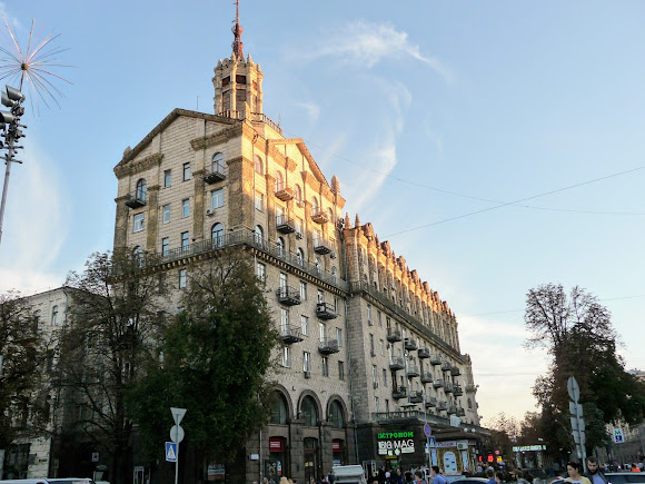 |
| Kyiv. Khreshchatyk, 13. The House with a Star. 1951 |
 |
| Kyiv. Khreshchatyk, 25. The House with a Star. 1954 |
Today Khreshchatyk is the widest (up to 100 m) and shortest (1,255 m) among the main streets of the megacity capitals.
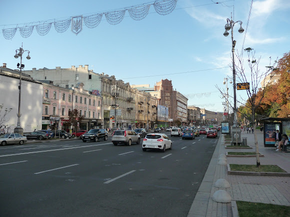 |
| Kyiv. Khreshchatyk |
Here are located the Kyiv State Administration, ministries, banks and the TSUM department store, and during working hours Khreshchatyk is one huge business centre.
 |
| Kyiv. Khreshchatyk. The Kyiv City State Administration. 1957 |
 |
| Kyiv. Khreshchatyk. TSUM. 1939 |
 |
| Kyiv. Khreshchatyk. The Tchaikovsky National Music Academy |
And at weekends not only the capital's residents gather here but all the visiting folk too, to feel the flavour of Ukraine's capital. On Khreshchatyk artists and musicians, dancers and clowns, magicians and acrobats perform a varied concert programme. You can take part in contests, social surveys, the filming of TV shows and rallies. For lovers of shopping the doors are open at the Passage, at TSUM and at the "Globus" shopping centre, which people popularly call "Dniproges".
 |
| Kyiv. Khreshchatyk, 15. The Passage. 1914 |
Coordinates:
50°26’53"N 30°31’20"E
Strolling along Khreshchatyk, one cannot pass by Independence Square without feeling oneself a part of the vast, friendly community of pedestrians and travellers gathered on the country's most famous square.
 |
| Kyiv. Khreshchatyk. Independence Square |
 |
| Kyiv. Khreshchatyk. Independence Square |
Coordinates:
50°27’0"N 30°31’27"E
The capital has yet another famous street for a leisurely promenade, but I shall tell of it at the end of the journey; for now let us take a walk along the most famous street in the Southern Palmyra. Derybasivska is named after the city governor Jose de Ribas, whose monument stands at the start of the street.
 |
| Odesa. Derybasivska Street. The monument to Jose de Ribas |
It is always noisy here, and the old is combined with the new. In almost every building with the status of an architectural monument there are modern shops, shopping centres, and creative restaurants and cafes.
 |
| Odesa. Derybasivska Street. A hotel. 1904 |
 |
| Odesa. Derybasivska Street, 33. The Passage. 1899 |
 |
| Derybasivska Street, 22. "Kino-Utochkino". The oldest cinema in Odesa. 1880s |
Adjoining Derybasivska is its contemporary and companion — the City Garden, without which it is impossible to imagine the Pearl by the Sea, and the original sculptures that have adorned this place of meetings and rest have become symbols of
Odesa.
 |
| Odesa. Derybasivska Street. The City Garden. The sculpture of the Lion |
 |
| Odesa. Derybasivska Street. The City Garden. The monument to the Odesan L. O. Utyosov |
 |
| Odesa. Derybasivska Street. The City Garden. The 12th chair on the smallest square, named after Ostap Bender |
 |
| Odesa. Derybasivska Street. The City Garden. The sculpture "Odesa Time" |
Derybasivska is loved by writers, composers and film directors, who often sing its praises in their works.
 |
| Odesa. Derybasivska Street. The City Garden. A gazebo and a fountain |
Coordinates:
46°29’2"N 30°44’19"E
Resort towns are simply obliged to have a pedestrian zone.
Henichesk has already done much for this, and, apart from the sea, tourists' favourite place of rest is Myru Avenue, with its place in the sun, a fountain, a sundial and cafes.
 |
| Henichesk. Kherson region. Myru Avenue. The pedestrian zone |
Coordinates:
46°10’16"N 34°48’47"E
In
Kherson on the pedestrian street it will be interesting to get acquainted with the historic buildings, including seeing the house that once held the headquarters of O. V. Suvorov, in whose honour the street is named.
Coordinates:
46°37’51"N 32°36’36"E
The longest pedestrian street in Ukraine is the central street of
Mykolaiv, which has had its historic name restored — Soborna. If 1.5 kilometres seem a tiring distance, you can rest in the Chestnut public garden, where a monument stands to the patron of this city of shipbuilders, St. Nicholas.
 |
| Mykolaiv. Soborna Street. The monument to St. Nicholas — patron of the city of shipbuilders |
Coordinates:
46°37’51"N 32°36’36"E
The most pedestrian streets have been created in the west of Ukraine. In order to preserve the historic monuments that are under UNESCO protection, Rynok Square in
Lviv has been declared pedestrian since 2011. It is the most popular tourist spot in this city of riddles, museums, coffee, dreams, legends, parks, old buildings and all, all things most unusual. The 44 houses, built in the 14th-19th centuries, form the architectural ensemble of the historic core of the Ukrainian Piedmont.
 |
| Lviv. Rynok Square, 4. The Black House. 1589. Renaissance |
 |
| Lviv. Rynok Square, 24. The Massari House. 1350. 1527. Renaissance |
Rynok Square was founded in the 13th century under Prince Lev Danylovych, and until 1944 vegetables, fruit and flowers were traded on it. The city administration has always been housed in the Town Hall, and entry there is open.
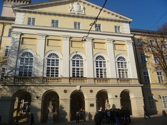 |
| Lviv. Rynok Square, 1. The Town Hall. 1830s |
Having overcome the 408 steps to climb the 60-metre clock tower, you will be treated to a wonderful panorama of the Royal City.
 |
| Lviv. Rynok Square, 1. The Town Hall. The clock tower. The "Neptune" fountain. 1793 |
And if the pedestrian has grown tired, then, having ridden across the square on the little sightseeing tram and looked into the finest coffee houses and confectioneries, he will race off at full steam to get acquainted with the cultural capital of Ukraine.
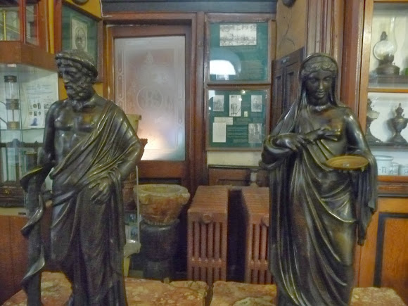 |
| Lviv. The Pharmacy-Museum |
 |
| Lviv. Rynok Square, 10. The coffee house "Lviv Coffee Mine" |
Coordinates:
49°50’30"N 24°1’53"E
In
Zolochiv in the Lviv region, Markiian Shashkevych Street is pedestrian from Vichevyi Square, where a monument stands to the Ukrainian poet and enlightener in whose honour the street is named, up to Independence Square with its monument to the Hero of Ukraine Viacheslav Chornovil.
 |
| Zolochiv. Markiian Shashkevych Street. The pedestrian zone |
 |
| Zolochiv. Markiian Shashkevych Street. The monument to Viacheslav Chornovil |
In the pedestrian zone, about 400 metres long, stands the town hall with a clock that shows the exact time.
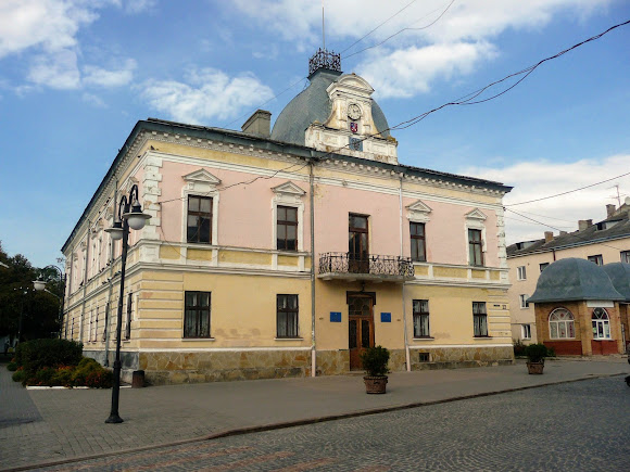 |
| Zolochiv. Markiian Shashkevych Street. The Town Hall |
The Orthodox Church of the Resurrection of the Lord was built in 1628 by Jan Sobieski in the Renaissance style.
 |
| Zolochiv. Markiian Shashkevych Street. The Church of the Resurrection. 1604 |
From here it is a stone's throw to the main landmark of the old town — the 16th-century Zolochiv Castle.
Coordinates:
49°47’56"N 24°54’4"E
In
Ternopil Hetman Sahaidachnyi Street, about 350 metres long, looks especially festive in May, when the chestnuts are in bloom.
 |
| Ternopil. Hetman Sahaidachnyi Street, 7 |
 |
| Ternopil. Hetman Sahaidachnyi Street, 13. The Art Gallery |
 |
| Ternopil. Hetman Sahaidachnyi Street, 3 |
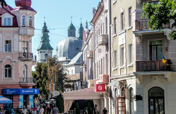 |
| Ternopil. Hetman Sahaidachnyi Street |
At the start of the street stands the Church of the Immaculate Conception of the Virgin Mary, built in 1779, in the past a Dominican church.
 |
| Ternopil. Hetman Sahaidachnyi Street. The Church of the Immaculate Conception of the Virgin Mary. 1779 |
Tourists will find it interesting to look at a map of the city from the early 20th century, made in the form of a model, and to walk along the Walk of Stars dedicated to distinguished Ternopil residents.
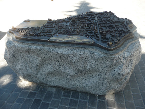 |
| Ternopil. Hetman Sahaidachnyi Street. The map-model of the city |
You can listen to the performances of professional and amateur performers who play by the monument to I. Ya. Franko from the summer verandas of the numerous cafes.
 |
| Ternopil. Hetman Sahaidachnyi Street. The monument to I. Ya. Franko. A performance by a musical group |
 |
| Ternopil. Hetman Sahaidachnyi Street. A summer cafe |
Coordinates:
49°33’9"N 25°35’34"E
The pedestrian promenade continues on Valova — one of the oldest streets of Ternopil, which arose in the 18th century on the site of a dismantled rampart.
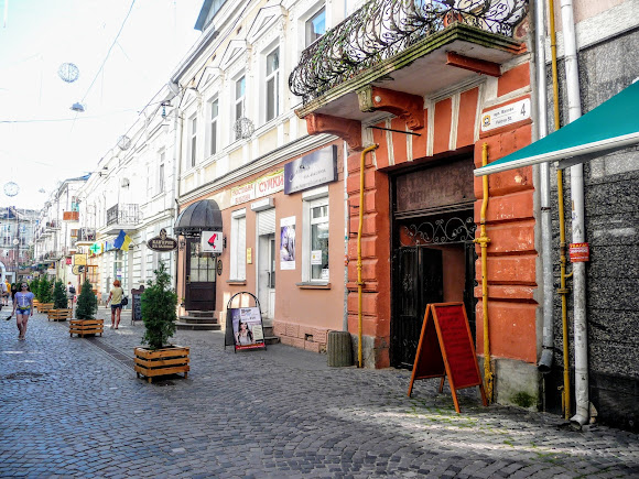 |
| Ternopil. Valova Street. The pedestrian zone |
It was almost undamaged during the Second World War, and all its houses have the status of architectural monuments. It is a favourite street of the creative beau monde, and it can be seen in paintings, and likewise bought as a keepsake of one's stay in this fine city.
 |
| Ternopil. Valova Street, 5. A wall with the inscription "Before I die, I want to ...", where anyone who wishes can share their plans and dream by writing it in chalk on a special board |
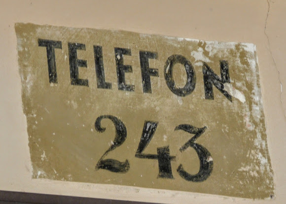 |
| Ternopil. Valova Street. A painted telephone number surviving from pre-war times |
Coordinates:
49°33’7"N 25°35’33"E
One of the most refined pedestrian streets in Ukraine is in Chernivtsi and bears the name of the Ukrainian writer Olha Kobylianska. You can read about it
here.
Coordinates:
48°17’18"N 25°56’14"E
In Zakarpattia pedestrian streets appeared much earlier than in other regions. A place for strolling is called a "Corso" here. In Mukachevo such a corso is the Square of Cyril and Methodius, about which you can find out
here.
Coordinates:
48°26’28"N 22°43’13"E
And in another Zakarpattia district centre, Berehove, the so-called corso is Kossuth Square, named after the Hungarian statesman. Over 350 metres you can see buildings representing various architectural styles.
 |
| Berehove. Kossuth Square. The Gyula Illyes Hungarian National Theatre |
 |
| Berehove. Kossuth Square. The Ferenc Rakoczi II Transcarpathian Hungarian Institute. The former Palace of Justice. 1904 |
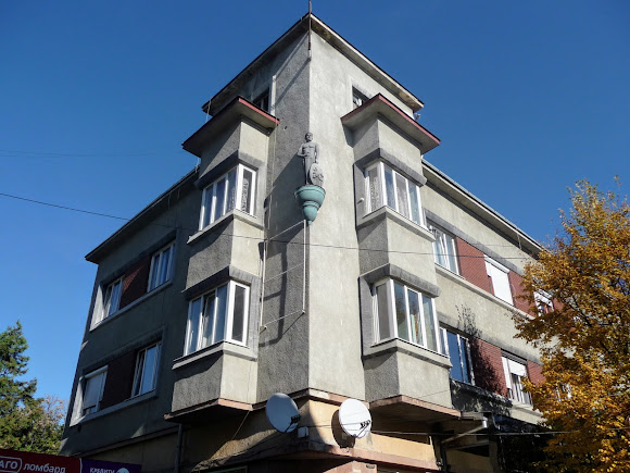 |
| Berehove. Kossuth Square. A residential building. Style: Constructivism. A sculpture of a warrior-guardian |
The Reformed Church was built in the 18th century, but the fire of 1918 caused damage. In 1922 the church was restored.
 |
| Berehove. Kossuth Square. The Reformed Church |
The names and signboards are written in the Latin alphabet. In the cafes you will be offered the finest wines of all sorts from local grapes. Adjoining the square is a public garden where the pedestrian can rest, admire the fountains and, glancing at the domes of the many churches, continue to get acquainted with the historical heritage of Berehsas.
 |
| Berehove. Kossuth Square. The monument to Gyula Illyes — the Hungarian writer and public figure |
Coordinates:
48°12’22"N 22°38’36"E
Those holidaying in
Morshyn are prescribed walks in the fresh air as a health-improving procedure. Part of Ivan Franko Street has been freed from vehicle traffic.
 |
| Morshyn. Ivan Franko Street. The "Lavanda" sanatorium |
In front of the Palace of Culture, folk festivities, performances and singing are held.
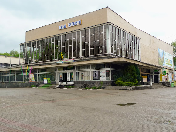 |
| Morshyn. Ivan Franko Street. The Palace of Culture |
The whole street is literally crammed with little shops and restaurants and cafes that break diet no. 5. The street has a green zone with a sculpted lion, leaping squirrels and an old pump room — the symbol of the resort.
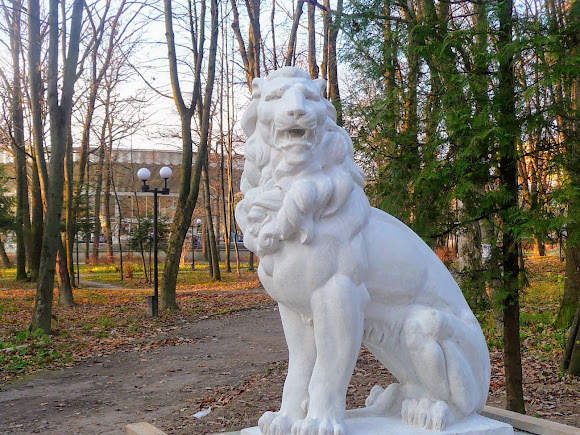 |
| Morshyn. Ivan Franko Street. The public garden. The sculpture of a lion |
 |
| Morshyn. Ivan Franko Street. The public garden |
 |
| Morshyn. Ivan Franko Street. The public garden. The former pump room — the symbol of Morshyn |
A quick march along this street is, for most of the resort-goers, a daily and repeated affair.
 |
| Morshyn. Ivan Franko Street. The lamps |
Coordinates:
49°9’0"N 23°52’13"E
From the west let us move to the north of Ukraine and see where a pedestrian tourist can take a stroll there.
 |
| Sumy. Soborna Street. The pedestrian zone |
In
Sumy two parallel streets, Voskresenska (435 metres) and Soborna (490 metres), together with their side lanes, make up a pedestrian zone for a non stop stroll.
 |
| Sumy. Voskresenska Street. The pedestrian zone. The lindens in bloom |
 |
| Sumy. Voskresenska Street. The pedestrian zone |
 |
| Sumy. Voskresenska Street. The sculpture of the sweet-tooths. A tribute to the Kharytonenko sugar business, thanks to which the city achieved prosperity in the 19th century |
 |
| Sumy. Voskresenska Street. The pedestrian zone |
On Voskresenska stands the Holy Resurrection Cathedral, built in 1702 in the style of Ukrainian (Cossack) Baroque. It performed defensive functions and is the first stone building in the city.
 |
| Sumy. Voskresenska Street. The Holy Resurrection Cathedral. 1702 |
The most majestic church in Sumy was built on Soborna in 1778. The English chimes on the 56-metre bell tower will always help the tourist to manage their time effectively.
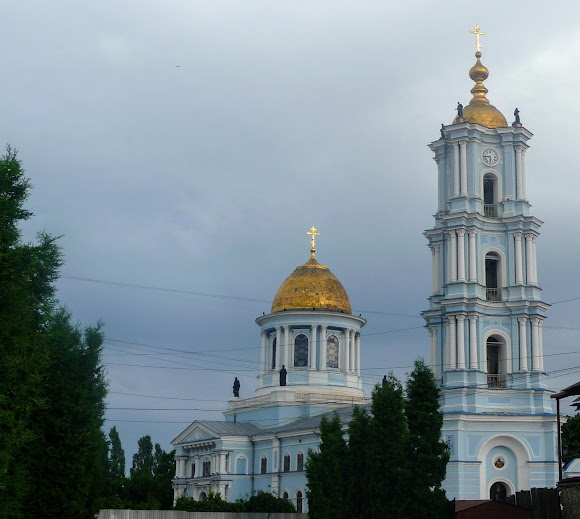 |
| Sumy. Soborna Street. The Holy Transfiguration Cathedral. 1778 |
And in the restaurants and cafes one can restore one's spent strength and continue the journey around the city.
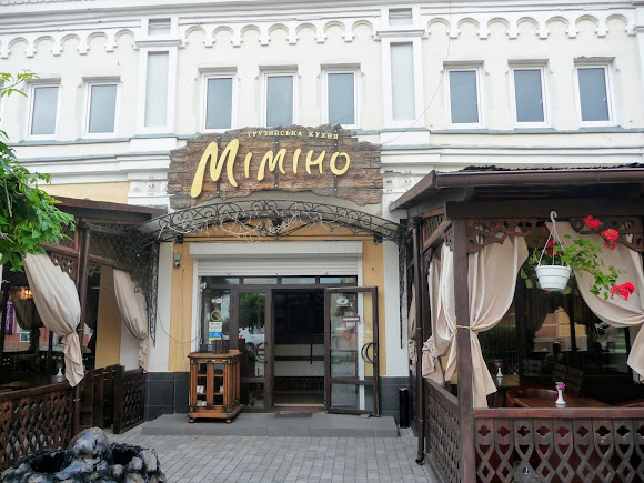 |
| Sumy. Voskresenska Street. A restaurant and cafe |
Coordinates:
50°54’33"N 34°48’1"E
In
Konotop, a city with a tram line built by the method of 'popular construction' — that is, by a voluntary-compulsory method — there is also an Arbat of its own, with shops and flower beds. The 180 metres of one of the city's longest streets, Brativ Luzaniv, is called the Konotop Boulevard by the residents, and its main landmark is the monument to the horse that gave the city its name and became its symbol.
 |
| Konotop. Brativ Luzaniv Street. The pedestrian zone. The monument to the horse |
Coordinates:
51°14’14"N 33° 2’31"E
If you happen to find yourself in Zhytomyr, you absolutely must visit Mykhailivska Street. You can read in detail about one of the oldest and most beloved streets of the people of Zhytomyr
here. Coordinates:
50°15’1 "N 28°39’53"E
Nizhyn, our quiet and cosy Nizhyn, invites travellers to get acquainted with its history, starting with the pedestrian street named after M. V. Hohol. To the classic writer, who was educated at the Nizhyn Gymnasium of Higher Sciences and read his first works in this beautiful city, a monument was erected in a public garden in 1881, and the oldest street has not changed its name since those times.
 |
| Nizhyn. Hoholia Street. The public garden. The monument to M. V. Hohol |
Nizhyn is a city where the churches are packed close together, and some of the old religious buildings are on Hoholia Street. St. Nicholas Cathedral dates from the middle of the 17th century. The oldest stone structure on the Left Bank has the status of an architectural monument of national significance.
 |
| Nizhyn. Hoholia Street. The Cathedral of St. Nicholas the Wonderworker. 1668 |
The same status is held by the Holy Annunciation Monastery and the Annunciation Cathedral, built in 1716.
 |
| Nizhyn. Hoholia Street. The Annunciation Cathedral. 1716 |
An information board listing all the numerous landmarks will help the tourist to decide on their further route.
 |
| Nizhyn. Hoholia Street. The information board of the city's landmarks |
Coordinates:
51°2’51"N 31°53’3"E
From provincial Nizhyn it is only 2 hours to the capital by suburban train, and we shall end our acquaintance with the pedestrian streets of Ukraine on Andriivskyi Descent.
 |
| Kyiv. Andriivskyi Descent. The pedestrian zone |
Celebrities have always lived on the Kyiv Montmartre, and in its buildings there are theatres, museums, art galleries, exhibitions and restaurants.
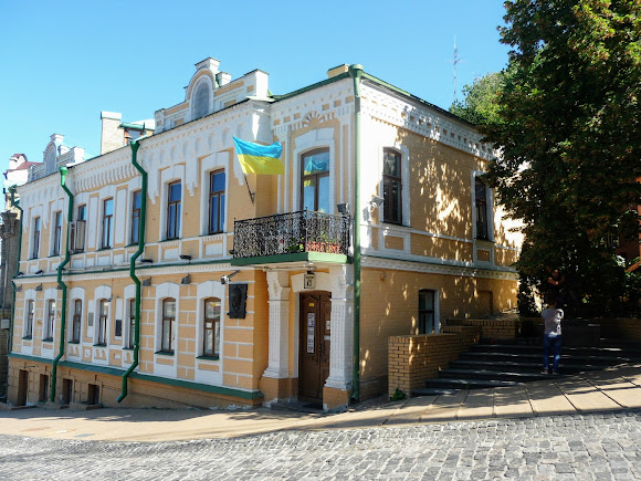 |
| Kyiv. Andriivskyi Descent, 13. The M. O. Bulgakov House-Museum |
 |
| Kyiv. Andriivskyi Descent, 34. 1901 |
 |
| Kyiv. Andriivskyi Descent, 19a. The "Kanapa" restaurant-salon |
A short route joining the Upper and Lower Town appeared in the times of Kyivan Rus. In the 18th century St. Andrew's Church was built on the hill in honour of Andrew the First-Called, who set up a cross on the site of the future capital city. Hence the name of the descent.
 |
| Kyiv. Andriivskyi Descent. St. Andrew's Church. 1767 |
On the 700-metre street-museum the vernissages of renowned masters give way to exhibitions of folk craftsmen. It was along this very street that the beloved film characters Pronia Prokopivna and the ladykiller Svyryd Holokhvastyi took their strolls.
 |
| Kyiv. Andriivskyi Descent. The monument to Pronia Prokopivna and Svyryd Petrovych Holokhvastyi |
Coordinates:
50°27’35"N 30°30’59"E
I wish you pleasant and instructive excursions along our pedestrian streets and squares — strolls solo, with a companion or in company.
 |
| Kyiv. Khreshchatyk |


No comments:
Post a Comment
Leave your impression